
Coastal structures (ports, piers, breakwaters, shore defences, etc.) must be designed as cost-effectively as possible. To achieve this, high-quality information is essential. Often geology and a geodetic base plan at the location of the object is available, but coastal processes (including waves and water levels) are barely assessed. This, however, is a vital input as a coastal structure is meant to withstand in marine environment. We intend to fulfil this gap and assist customer with our expertise and services from first idea till maintenance of a new structure.
Analysis of water levels
The analysis of water levels is necessary for coastal structures and management. High levels allow waves to approach closer to shore, exerting high loads. Low levels on the other can cause problems in navigation. Lainemodel OÜ uses both modelled and measured values in its work. We calculate site-specific averages, trends, extreme values and water levels corresponding to different return periods and seasons. We also analyse their duration and impact on the surrounding area. It makes a big difference whether a flood lasts 2 hours or 2 days.
Water levels on Estonian and Latvian coasts are high in autumn and winter and rather low in summer. Such seasonality plays an important role in the design of ports and coastal protection facilities. For example, the retaining wall on the sea side of the promenade can be built so that the waves peak over it in winter and autumn. However, in summer, when there are many people on the promenade, this danger is unlikely. Therefore, when designing the facility, you can decide in favour of a lower seawall, which would bring significant savings.
When determining the design water levels, possible simultaneous high waves must be considered depending on the location. Such a wave run-up causes the sand slopes on the beach to break and scour in front of the foundations. On beaches open to the southwest and south, the coincidence of high-water levels and waves is common, in Northern Estonia it is more random. This must also be considered when designing facilities to ensure the most cost-effective solution.
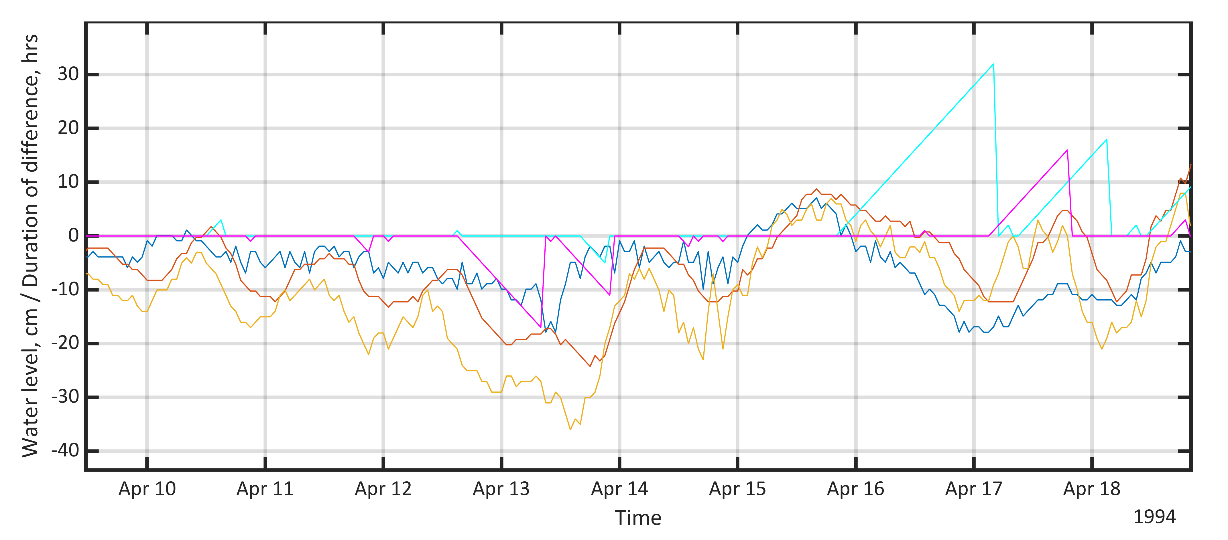
Dynamics of water levels. Blue - water level at Liepaja, red - water level at Daugavgriva, orange - water level at Pärnu, light blue - duration of 5 cm difference between Daugavgriva and Liepaja, pink - duration of 5 cm difference between Pärnu and Liepaja.
We have been particularly involved in the study of the dynamics of water levels in the Gulf of Riga and have published scientific articles on this topic. Furthermore, Rain Männikus wrote his thesis on Latvian water levels. In addition, we have studied the water levels of the rest of the Baltic and Finnish coasts.
Modeling and analysis of wave parameters
As coastal structures must withstand in marine environment, it is necessary to quantify possible loads. This can be done with wave climate analysis. Based on the results, the designer can ensure the most efficient construction possible, and the client mitigates possible risks. In several cases, our work has resulted in a great financial gain for the customer.
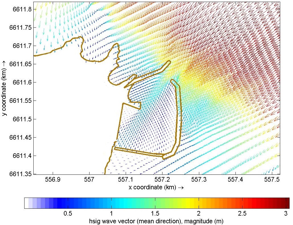
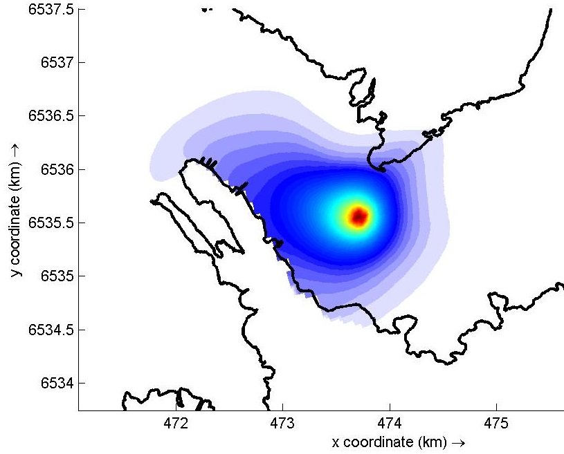
Modeled significant wave heights near the port of Kelnase, Estonia
We model the wave parameters mainly with the SWAN wave model developed in Delft, the Netherlands. We constantly improve our knowledge in courses and trainings in order to offer more modern solutions. We have participated in wind and ship wave modeling and field measurements at Tallinn University of Technology. We have conducted measurements at Tallinn, Virtsu, Käsmu, Pärnu and Kihnu.
Modeling and expertise of coastal processes and sediment movement
When constructing coastal structures, it is very important to consider the pattern of sediment movement. This must be kept in mind especially in the context of increasingly warm winters, where the cold crust that protects beach sand does not form. In this way, erosion can intensify near the structure built on the beach or further away. More details can be found in the article published in local newspaper Postimees. The problem may not only be erosion on the beach and neighbouring buildings, but also accumulation where it is not desired. For example, in the case of a new port, it is sad if, as a result of insufficient studies, it appears that the mouth of the port is filled with sediment.
Beach processes must be known before building a new facility on the beach. The changes that occur when changing new or old can be seen even kilometers away. Therefore, they should already be considered during general planning at the municipality level. We have provided our studies to various Environmental Impact Assessments (EIA).
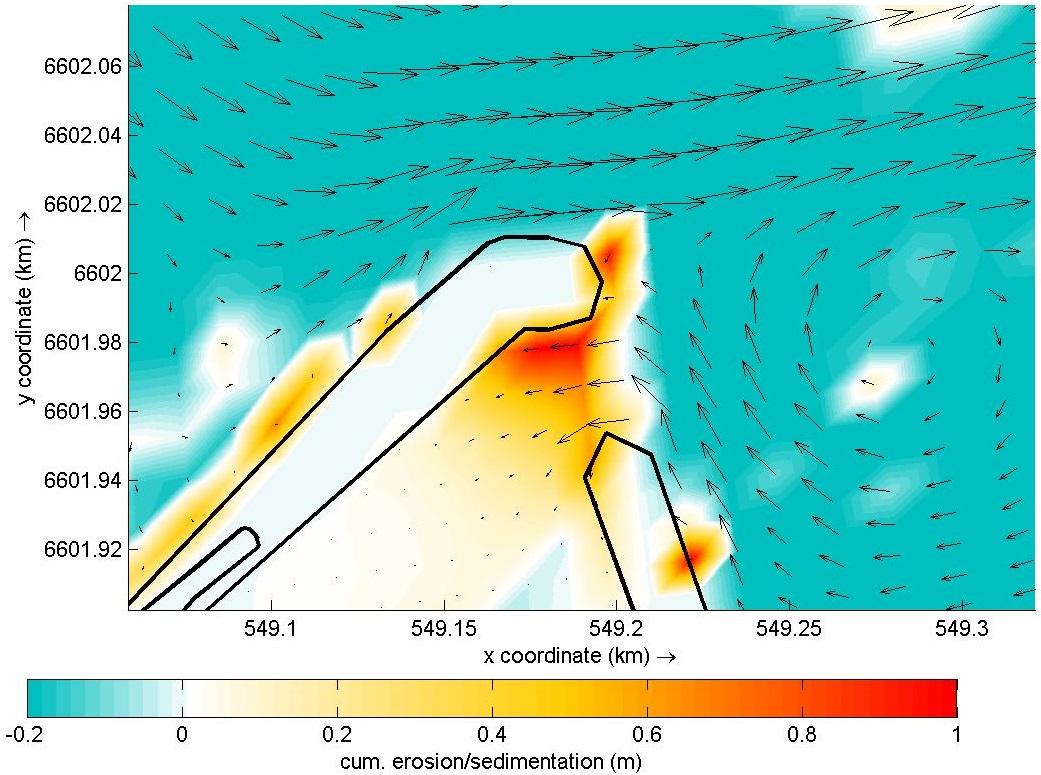
Movement of currents and erosion and accumulation of sediments at Leppneeme, Estonia
Lainemodel Ltd analyzes coastal processes with existing measurements, monitoring and numerical models. Another important direction is the modeling of the movement of suspended particles, which is especially important in dredging and dumping. We have carried out several evaluations for EIAs.
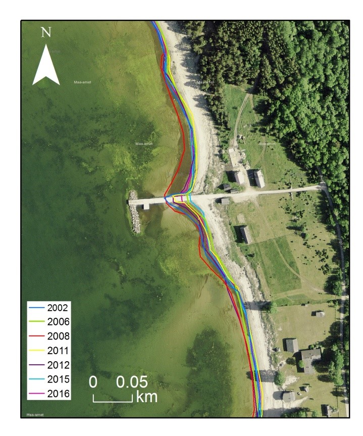
Changing the coastline in Matsi, Estonia
Assessment of oil, temperature or nutrient (nitrogen, phosphorus, etc.) distribution
When planning the discharge of waste water or extracting water from sea, its impact on the surrounding environment must be analyzed. Modeling plays an important role here. By doing this, a model must be built at the beginning, which must be calibrated and validated according to the existing situation. After that, it is possible to test different scenarios and achieve the best result.
Nutrient distribution in Haapsalu Bay, Estonia, at one possible discharge location
Depending on the situation, either simple or more complex models are used. Both waste water discharge, water intake, and suspended solids cause by dumping and dredging have been analyzed.
Wind dataset analysis
The use of correct wind data is of great importance in the analysis of waves, currents and coastal processes. It is important to know the wind speed and direction at sea, but it is not usually measured there. The first thing that comes to mind is that you could use the winds from coastal stations and interpolate or extrapolate them to the sea. In this case, however, the following criteria must be considered:
1. There are no local obstructions in the open sea, so strong winds at a coastal station must generally blow from the same direction as most weak winds.
2. The extreme wind speed must obey some known probability distribution.
3. The average value of the wind speeds must be proportional to the sea breezes
4. At sea, the daily variation of wind speed is small.
Based on these criteria, a suitable measuring station can be selected for further work. This is important because underestimating the wind also underestimates the waves.
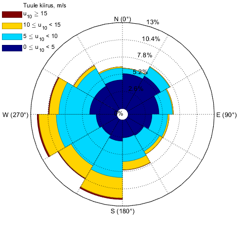
Winds at Kihnu, Estonia, measurement station in 1985-2015.